


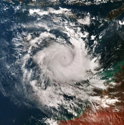
This wide view of Copernicus Sentinel-3 shows Cyclone Errol heading towards the coast of Western Australia.
Zoom in to explore this image at its full resolution.
Errol was a powerful tropical cyclone, which formed as a tropical storm at the beginning of April 2025 and rapidly intensified while moving towards northern Australia, passing from category 1 to 5 in 30 hours.
On 16 April, when this image was acquired by Sentinel-3’s Ocean and Land Colour Instrument, Errol reached its peak intensity with wind gusts of 285 km/h. The typical pinhole eye – a small, well-defined eye often associated with powerful and rapidly intensifying tropical cyclones – is clearly visible in the image.
Despite its intensity, Errol quickly weakened the following day, as it moved towards Australia. This limited its impact and damage on land to heavy rains in remote areas of the Kimberley region coast, which is visible in the cloud-free portion at the bottom of the image.
Tropical cyclones originate over warm oceans. When they form in the northern hemisphere, they are referred to as hurricanes or typhoons, while those forming in the southern hemisphere are called cyclones.
Satellites orbiting Earth can provide indispensable up-to-date information on such events that cover entire regions, as shown here from Copernicus Sentinel-3. The width of the storm in this image is estimated to be over 500 km. The mission is designed to measure, monitor and understand large-scale global dynamics and provides essential information in near-real time for ocean and weather forecasting.
Source: ESA


Be the first to comment on "Earth from Space: Cyclone Errol"