


EUMETSAT has released the first Earth images from its METimage instrument on board the recently launched Metop Second Generation A1 (Metop-SGA1) satellite, with these early teasers showcasing the exquisite detail, true-to-life colour, and data products that will ultimately support national weather services in improving forecasts that save lives, protect communities and benefit economies.
The satellite, its instruments and the ground-based infrastructure required to process images are currently undergoing testing, calibration, and validation. When these crucial activities have been completed, images will be produced and released operationally for use in weather forecasts and other key services.
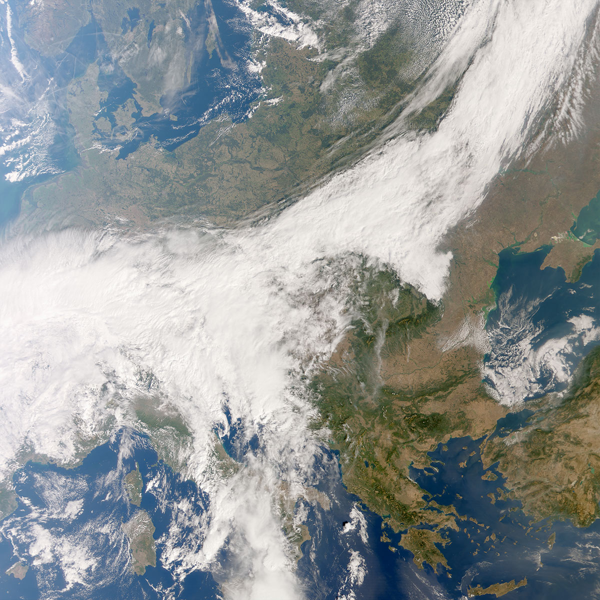
Captured on 24 September 2025, METimage’s first scene spans Europe and North Africa, revealing intricate cloud structures linked to a cold front over central Europe, storm activity building over the Adriatic and central Mediterranean, and – under clear skies – vivid surface features such as the forests of the Carpathian and Balkan mountains, glistening lakes in Türkiye, and stark contrasts between North Africa’s deserts and greener terrain.
Subsequent pictures from the instruments first global sweep of images include dramatic views of Hurricane Humberto over the Atlantic and Tropical Storm Neoguri over the Pacific, vivid shifts in ocean colour from stirred sediments and bright sands in the Caribbean and off Australia, fog blanketing the US Great Lakes, and a cloud-free panorama of Asia with the Himalayas detailed down to individual snow-filled valleys.
Travelling around 830 kilometres above Earth in a polar, sun-synchronous orbit on Metop-SGA1, METimage is a new multi-spectral radiometer that provides near-global daily coverage. It observes in 20 visible-to-infrared channels at 500-metre resolution at nadir and with far sharper detail than its predecessor, the Advanced Very High Resolution Radiometer (AVHRR) on first-generation Metop satellites, which has a one-kilometre resolution at nadir. This capability supports precise observations of clouds, water vapour and aerosols, land and ocean surface temperatures, ice cover, vegetation and even active fires.
Specialists have also delivered early versions of the first data products, such as detailed cloud maps – vital tools for forecasts and for improving the performance of other satellite instruments, providing early glimpses of the power of METimage observations to strengthen numerical weather prediction, improve storm nowcasting, speed up wildfire detection, and support improved air-quality forecasts.
“In a year of deadly floods, searing heatwaves and devastating wildfires in Europe, the need for precise forecasts has never been clearer,” said Phil Evans, EUMETSAT’s Director-General.
“The first METimage pictures are truly exceptional in detail and colours, and these data will help national meteorological and hydrological services deliver more reliable forecasts and earlier, targeted warnings, better protecting people and infrastructure, reducing disruption and supporting economies. Delivering imagery of this quality and so soon after launch is a remarkable achievement by teams at EUMETSAT, the European Space Agency, the German Space Agency at DLR (Deutsches Zentrum für Luft- und Raumfahrt; the German Aerospace Center), Airbus, our member states and international partners. Our focus now is to complete commissioning, fine-tune performance and provide operational data.”
Simonetta Cheli, ESA’s Director of Earth Observation Programmes, said, “These images not only highlight the role that Metop Second Generation will play in providing essential data for weather forecasting and climate monitoring – they also highlight the value of strong partnerships between ESA, EUMETSAT and other key industrial players. As we face increasingly erratic weather patterns, working together to deliver timely and precise data has never been more critical.”
Walther Pelzer, DLR Executive Board Member and Director General of the German Space Agency at DLR said: “The number of extreme weather events is increasing significantly. Our everyday weather forecasting is largely based on satellite data. Thanks to its high spatial resolution, METimage will make a key contribution towards improving forecast quality. By contributing this cutting-edge technology, Germany is setting new standards in precise climate observation and weather forecasting. The great quality of the data just delivered emphasises that the high expectations of METimage are fully met. METimage is the contribution of the German Space Agency at DLR to the EUMETSAT Polar System, jointly financed by the federal Ministry of Transport (BMV) and EUMETSAT.”
Europe in incredible detail
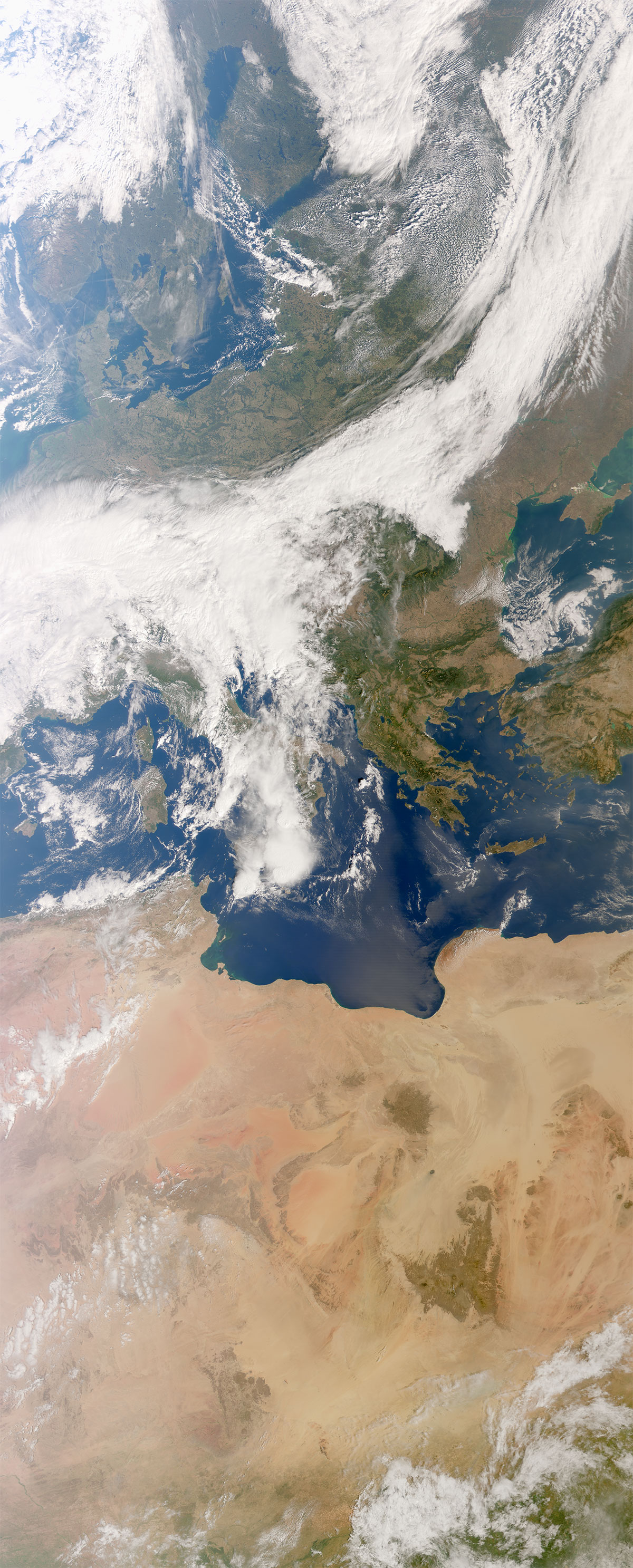
Captured between 10:43 and 10:59 CEST on 24 September, METimage’s very first image shows clouds connected with a cold weather front sweeping across central Europe and signs of convective storm activity developing over the Adriatic and central Mediterranean seas. High altitude, wispy cirrus clouds hint to potential turbulence over the Netherlands, Belgium and Luxembourg, while thin aircraft contrails are clearly visible over cloud-free western Denmark.
Where skies are clear, the Earth’s surface is revealed in fine detail: shimmering lakes can be seen in Türkiye, including the bright white salt flats of Lake Tuz, as well as the green landscapes of the Carpathians and Balkans, and Libya’s Waw an Namus volcanic caldera. Compared with AVHRR’s ~1 km resolution, METimage’s 500-metre view delivers about four times more detail, making it possible to pick out narrow cloud streets, thin valley fog and subtle coastal colour changes with far greater clarity.
AVHRR V METImage true colour
AVHRR natural colour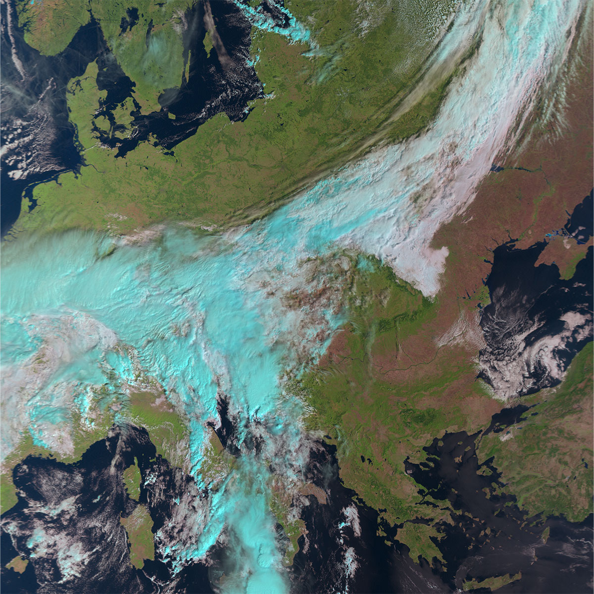
By zooming in on METimage’s first picture, cloud and land surface details can be seen in much more intricate detail in comparison to its predecessor, with images produced at much higher resolution at 500 meters at nadir in comparison to AVHRR’s one-kilometre resolution. As the instrument has more visible channels than AVHRR, it enables the creation of “true colour” red, blue, green (RGB) images.
Image: EUMETSAT
Seeing more by combining views
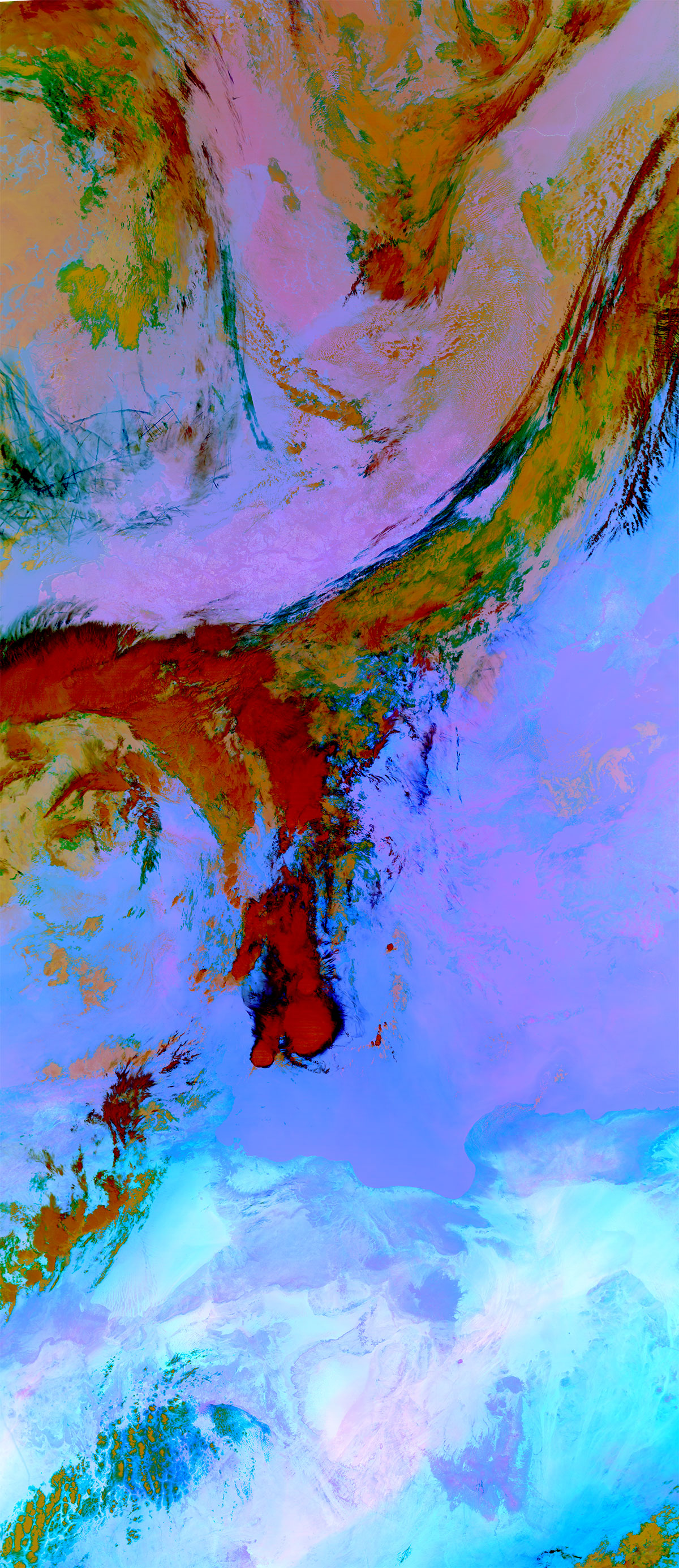
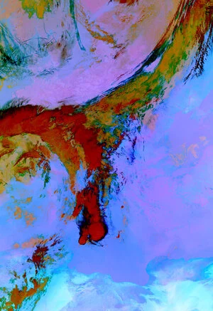
Composite images are created by combining data from different spectral channels observed by METimage, giving meteorologists a more complete picture than individual channels alone. This Dust RGB is made from three thermal-infrared channels of Earth observed by METimage in its first image. Different features have distinctive colours, so they stand out at a glance: airborne dust shows up in vivid magenta, making plumes easy to spot and track; thin, high cloud looks darker; and thick water cloud appears in cooler, bluish tones. The view reveals dust particles in the atmosphere and also hints at boundaries between moist and dry air near the surface and helps distinguish icy cloud tops from watery ones. These data will be invaluable for forecasting, aviation, air-quality advice and protecting health.
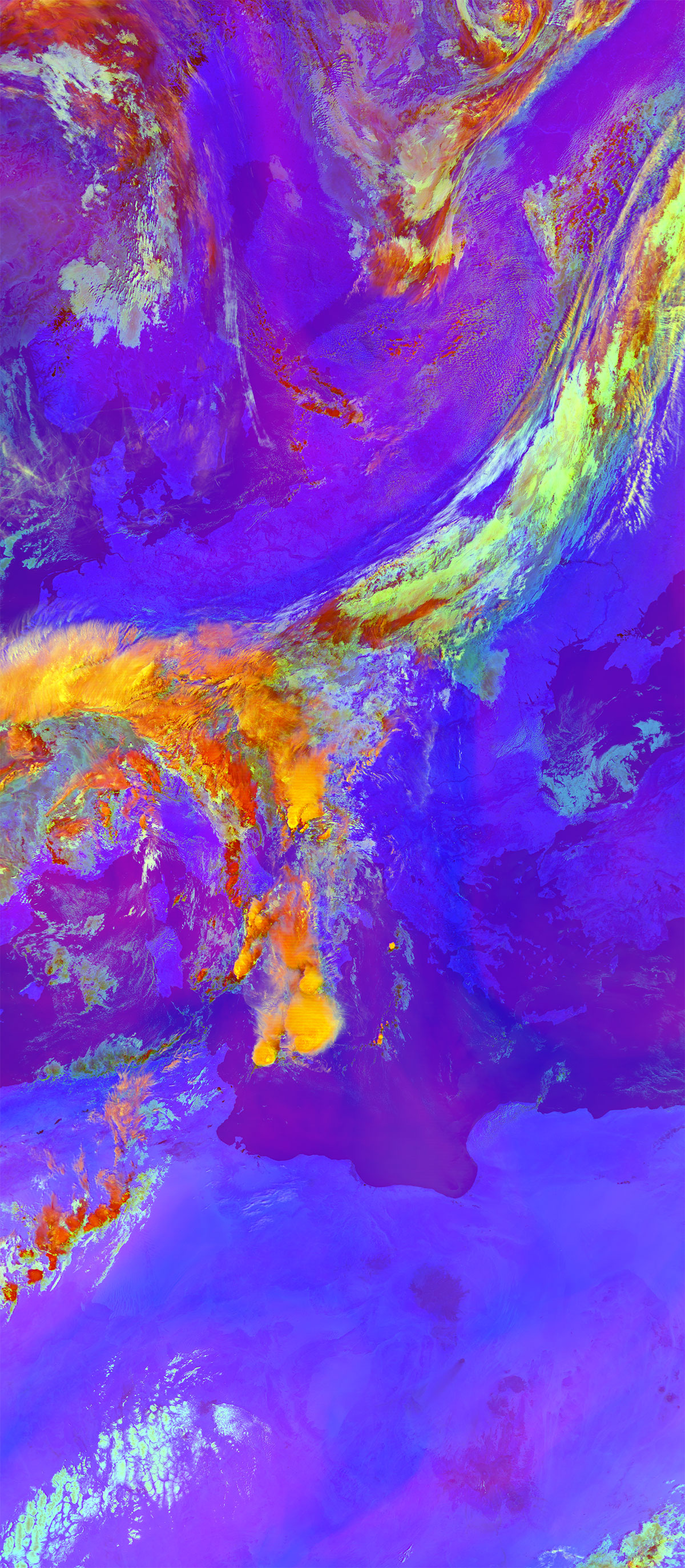
The Severe Storms RGB is another combined view designed to make dangerous thunderstorms appear clearly on screen by detailing the cloud top microphysics of high clouds. It brings together data from three METimage channels that detect moisture patterns high in the atmosphere, how clouds reflect light, and how much heat the clouds give off. This enables tall, rapidly growing storm clouds to be quickly identified as their tops are often packed with tiny ice crystals, which can be signs of strong updrafts and potential hazards to come like hail, severe winds and intense lightning. Forecasters will be able to use this view to help them to track storms, supporting faster, more targeted weather warnings.
Turning data into action
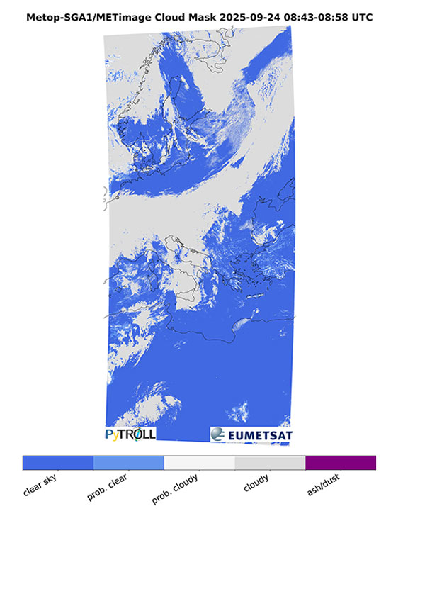
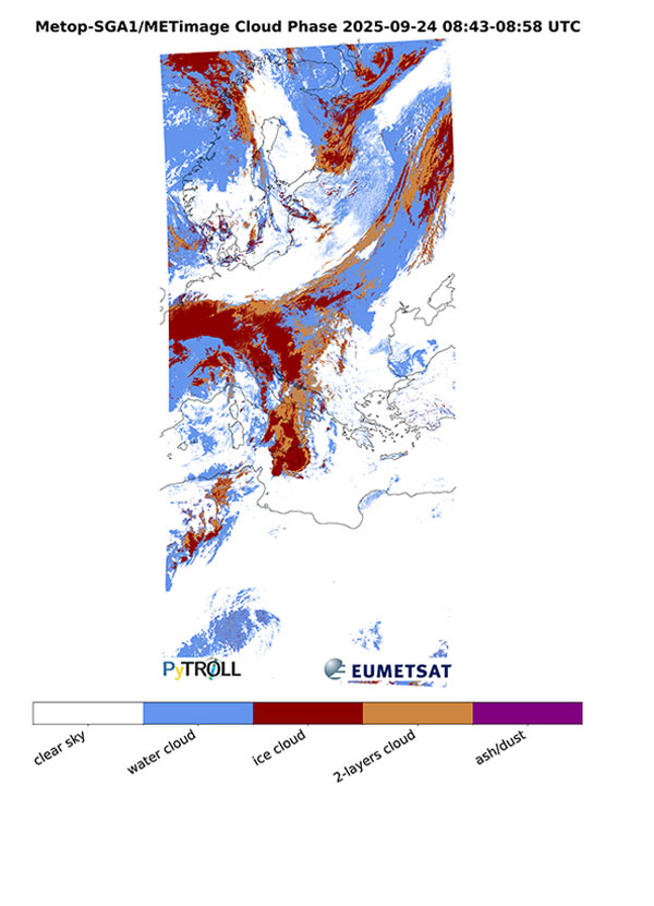
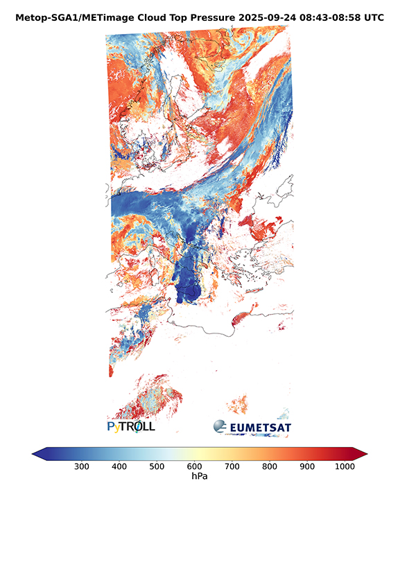
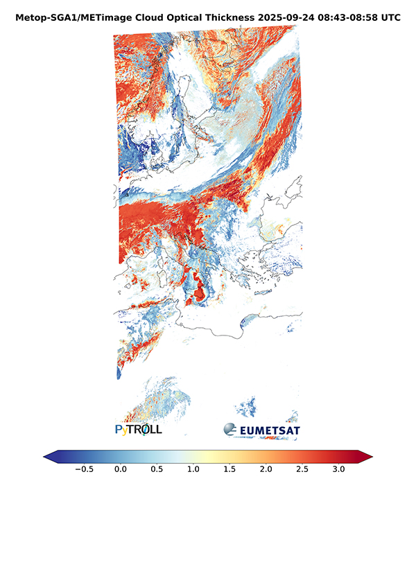
Because clouds form in layers, change rapidly and behave differently with altitude, they are among the hardest features to observe; early versions of METimage’s processed data products already show how the instrument’s data can provide cloud information in exceptional detail.
On the top-right, a preliminary “cloud mask” from METimage’s first image maps pixel by pixel where the instrument detects clouds and where it sees clear sky, with even very thin clouds and aircraft contrails over Scandinavia visible. Moreover, a series of three cloud products shows the phase (top-right), height (bottom-left), and thickness (bottom-right) of clouds across Europe, highlighting their layered and varying nature.
Once the instrument data become operational, they will provide invaluable insights for forecasting, climate monitoring, and improving the performance of other satellite instruments such as Metop-SG’s Infrared Atmospheric Sounding Interferometer – New Generation, which relies on precise cloud data to deliver its highly accurate temperature and humidity profiles.
Images: EUMETSAT
Dynamic conditions across the Americas

Taken on 25 September 2025 between 17:12 and 17:26 CEST, this METimage picture shows low cloud and fog over the Great Lakes with valley fog in Wisconsin, fair-weather cumulus clouds over Florida, and convective activity and possible storms developing south of Panama. Offshore, shallow stratocumulus clouds stretch from the Galápagos Islands toward the coast of mainland Ecuador, while sun glints indicate calmer winds south of Jamaica and along Cuba’s southern shore. Around the Yucatán Peninsula, milky blue-green waters reveal stirred-up sediment, while calmer seas around the Greater Antilles display striking blue tones that highlight the region’s bright white coastal sands.

Extreme weather in focus

METimage pictures Hurricane Humberto in full flow between 15:13 and 15:31 CEST on 26 September 2025. From its pole-to-pole orbit, Metop-SG provides vital data over the ocean regions where hurricanes and other severe weather systems form and intensify. By tracking clouds, temperature, humidity and wind, METimage will help forecasters understand storm evolution and likely paths, supporting earlier warnings and better storm resilience.

Spectacular detail in mountain regions

A view over Asia between 06:37 and 06:56 CEST on 26 September reveals the snow-capped Himalayas in sharp relief. Detailed surface observations and layered cloud structures highlight METimage’s phenomenal ability to detail the Earth’s land, oceans and atmosphere, vital for monitoring weather and climate processes affecting billions of people.

Near-global coverage
METimage flies on Metop-SGA1 in a Sun-synchronous polar orbit. Because the orbit keeps the satellite in step with the Sun, it crosses each area at about the same local time on every pass. The global image is composed by stitching together pictures from 23:30 CEST on 25 September to 00:09 CEST on 27 September 2025.
The consistent angle of sunlight in each image makes them directly comparable day-to-day and year-to-year. For weather services, this will mean frequent, uniform observations that feed numerical forecast models as well as nowcasting, especially at higher latitudes. For environmental monitoring, it will mean reliable time series to detect trends and impacts, such as mapping burn scars after wildfires, tracing dust and smoke, monitoring snow and ice cover, tracing coastal water-colour changes that reveal sediments and phytoplankton, and monitoring long-term climate change.
Source: ESA


Be the first to comment on "MetOp-SG’s METimage delivers first images"