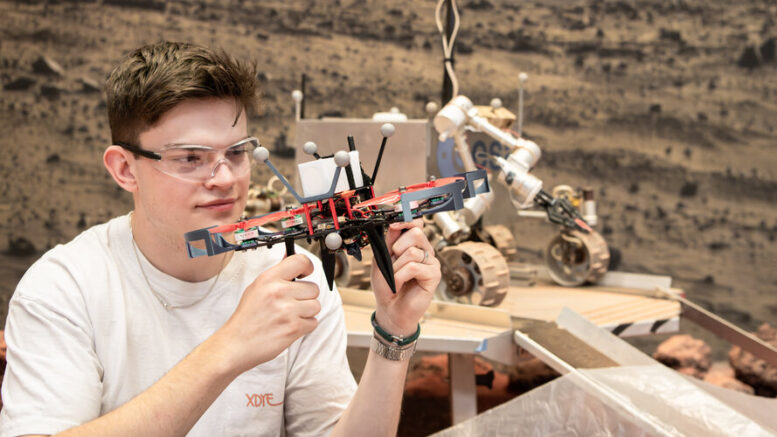
The martian landscape is not the easiest terrain to get around. Some areas are too rocky for a wheeled rover to cross, and elsewhere a lack of distinctive features in the landscape can cause problems for a camera-based navigation system. For a flying drone, such a navigation issue can mean the difference between a safe landing and a crash. Dielof van Loon, a student from Delft University of Technology, investigated what would happen if the two explorers – rover and drone – teamed up.

Typically, Mars rovers use a camera-based system to navigate the terrain of the Red Planet. Their main camera is attached to the top of a mast – a pole-like structure extending upwards from the robot’s main body, creating the characteristic rover look.
The taller the mast, the further into the distance the camera can see. But there’s a catch – the rover’s movement across uneven terrain can cause the mast to vibrate, resulting in blurry images and potentially affecting other functions of the rover. This way, the swaying motion also limits the rover’s speed.
To fix this issue, engineers have proposed adding a drone into the setup – one that could fly well above the rover to have a better view of the ground and would feed information about the surrounding terrain to the rover via a wireless connection. This would take the tall and heavy mast out of the equation, allowing the rover to drive faster.

The drone would serve another, secondary purpose: the draft from its propeller blades would clear away any fine martian dust from the rover’s solar panels.
However, a free-flying drone would still face the problem that vast and empty plains pose to autonomous navigation – an issue that spelled the end of NASA’s Ingenuity Mars Helicopter, the first and so far only aircraft to take off, fly and land on the surface of another planet.
Dielof van Loon, a student from Delft University of Technology, explored a possible solution during his internship at the European Space Agency’s Planetary Robotics Laboratory.
In his project, he investigated the potential of tether localisation, a technique that uses a physical tether attached to a drone to determine the drone’s location.

For even more accurate positioning information, Dielof combined this technique with inertial odometry, a method that uses an electronic device to determine the drone’s position and orientation, similarly to how a mobile phone knows to rotate its screen when tilted.
“My research project focused on a scenario in which a drone is tethered to a rover with a cable,” explains Dielof. “The cable would transmit data from the drone to the rover, and the rover would provide power and processing capacity, making the drone lighter and allowing it to fly for longer periods of time.”
In various test runs, Dielof’s drone flies three metres above a platform simulating a rover, moves in various flight patterns, for example a figure eight, in the air above, and lands again – the whole time attached with a tether to the platform.


Tethered drone testing
Access the video
“I created a system that allows me to measure the length of the tether currently unwound, as well as its angles at any given moment,” says Dielof.
“One sensor measures the tether’s angle at the point where it is attached to the drone, while the other measures it at the point where the tether enters the platform. The base station computer then uses the measurements from the two sensors, together with the tether length and tension measurements, to determine the drone’s position.”

In addition to the rover-simulating platform and tether management system, Dielof developed the necessary software and hardware and added them to a bare drone to suit his testing setup.
“Ultimately, in a real mission, the tether could be longer,” concludes Dielof. “The setup could also be extended to include two drones, one tethered and acting as a beacon for another, free-flying exploration drone.”
Lennart Puck of ESA’s Planetary Robotics Lab, Dielof’s internship supervisor, comments: “Dielof’s work has shown not only that a tethered drone is a viable concept for planetary exploration, but also that the tether itself can be used as a new means of localisation.
“This research highlights a pathway for future mission concepts, where tethered systems could operate as reliable extensions of surface-bound vehicles, combining mobility with robust localisation.”
Source: ESA


Be the first to comment on "The dynamic drone-rover duo with a special bond"